How to View County Lines on Google Maps
Do you want to view county lines on Google Maps?
Google Maps is one of the most popular web mapping platforms that provides detailed information about geographical locations, satellite imagery, 360° views of streets, street maps, route planning, directions, and real-time traffic conditions.
Apart from these features, Google Maps also offers some additional features such as an option to change map type and details using layers, create custom maps, and cloud-based custom map styling with over 250 customizations.
Well, Google Maps also gives an option to show county lines. However, this feature is hidden and most users are unaware of it.
So, in this post, I’ll show you how to view county lines on Google Maps.
What are County Lines on Google Maps?
County lines refer to the boundaries or divisions between different counties or administrative regions within a geographic area.
In Google Maps, you can see the boundaries of different administrative regions or counties depicted as lines/borders on the map.
These lines represent the limits of the respective counties or administrative regions and are often used for reference, navigation, and geographical information.
County lines on Google Maps can help users identify the boundaries between different areas, locate specific counties or regions, and understand the geography of a particular region or country.
Note that the accuracy and availability of county lines on Google Maps may vary depending on the location and the specific data used by Google.
County boundaries can change over time due to administrative updates, redistricting, or other factors, so it’s always recommended to verify the most up-to-date and authoritative sources for accurate boundary information.
How to View County Lines on Google Maps
If you’re using the Google Maps Web version or mobile app, you can show all or a single county with lines. You can even share and embed the map on a web page.
View All Counties on Google Maps
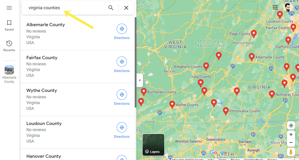
To view all counties in a specific state, you need to type the state name followed by counties word in the Google Maps search field. The word counties work as the search operator. However, you can also use the county word.
After searching, Google Maps shows all counties available in the state with pins.
Note that you can also use this method on Google Earth.
The step-by-step guide is given below.
- Open Google Maps on your device. If you’re using a desktop, open the web browser and open the https://www.google.com/maps/ URL. Otherwise, on a mobile phone, you can open the Google Maps app.
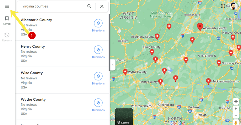
- Now you need to search for the counties.
On the web version, click on the Search Google Maps field, or on the mobile phone app tap on the Search Here field and type the state name followed by counties. For example, if you want to search for all counties in Virginia state, type Virginia Counties. - Now Google Maps shows all available counties on a map with marker pins. You’ll also see the list of counties.

- To see the county line and the information, click on the county and you’ll see the area boundary with a red dotted line.

- That’s all.
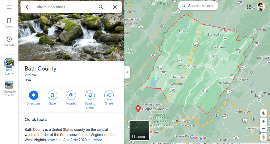
Note that when you tap on the county from search results on the Google Maps app for Android and iPhone, you can’t see the boundary line. To see the boundary line, you need to search for the particular county using search as discussed in the next method.
View One County with Boundary Line in Google Map
You can also do a direct search to view a single county with a line. For this, you need to know the county name. If you don’t know the county name, you should follow the first method. The steps are given below to view a single county line in Google Maps.
- Open a Google Maps app or web browser on your device using the https://www.google.com/maps/ URL.
- Now search for the county name followed by the county word using the search field.

- Google Maps shows the county with boundary lines.
- That’s it.
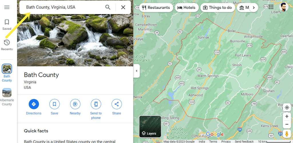
There are chances that different states and counties have counties with the same name. If you’re unable to search for the county, you might need to type the state and country name after the county name. For example, if you’re searching for Bath County in Virginia, then you can type Bath County, Virginia, USA.
How to Share Google Maps with County Lines
Google Maps allows us to share maps with links. You can share the link on social media platforms, emails, and messages to share the county.
Moreover, you can embed the county on websites. Google Maps offers the HTML code to embed the map in different sizes.
Share Google Maps with All Counties of the State
The steps are given below to share Google Maps with all Counties. Let’s get started.
- Open Google Maps on a web browser using the https://www.google.com/maps/ URL on a desktop.
- Now search for the counties of the state. To see all counties of the state, type the state name followed by counties in the search field.
- In the search results, Google Maps shows the list of counties and marked pins on a map.
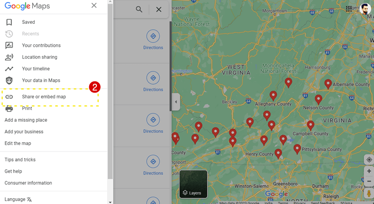
- Click on the Hamburger menu icon (three horizontal lines) from the top right of the page.

- Select the Share or Embed map option.

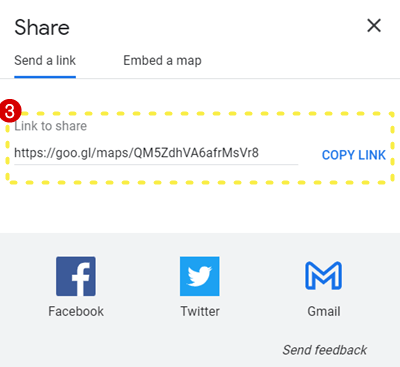
- From the popup, copy the link and share the link with others. You can directly share the link on Facebook, Twitter, and Gmail from the popup.

Alternatively, you can also copy the HTML code to embed the map on the website or web page from the popup. For this, click on the Embed a map option from the popup and copy the HTML code. You can also select the map size before copying the link. - That’s all.
Note that this method doesn’t work on mobile apps. On the app, you can get the share link of a single county.
Share Google Map with Single County Line
To share a single county with a boundary line, follow the following steps.
- Open Google Maps on a smartphone app or web browser.
- Using the search bar, search for the county by name. If you don’t know the name of the county, search for all counties.
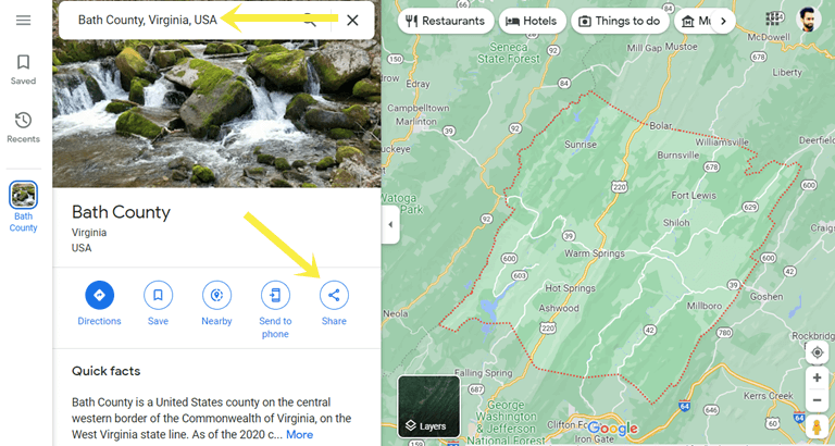
- Now from the search results, click on the county name and you’ll see the information tab.
- From the information tab, click on the Share option.

- Now the popup will be shown and you’ll see the link. Copy the link and share it with others. You can also copy the HTML embed code from the popup.
- That’s all.
Conclusion
I hope this article helped you learn how to view county lines on Google Maps. However, Google Maps doesn’t give the direct option to show the county lines. But, using the search operator, you can do this task. You can see the county boundaries on Google Maps web and mobile app for Android and iPhone. Note that, all countries don’t have counties.
Popular on OTW Right Now!


About The Author
Gagan Bhangu
Founder of otechworld.com and managing editor. He is a tech geek, web-developer, and blogger. He holds a master's degree in computer applications and making money online since 2015.